Interview: Leveraging satellite and AI technology to monitor construction projects
The sheer pace at which global construction development occurs dictates that an up-to-date, real-time view of any construction project is one of, if not the most valuable asset any business can possess. Imagine, for example, the potential of each scanning simple satellite data and imagery that reveals – to the smallest detail – progress or changes over the last 24 hours.
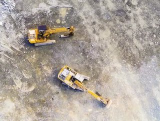
Such advanced technology can show that a crane has moved from its position two days ago meaning that a certain aspect of the build is complete, or that the position of people or equipment gives insight into exactly what’s happening on site at any given time. Such knowledge not only improves the entire project management process, but allows for better forward planning and decision making, and can give greater context to the wider construction market in any given sector.
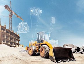
The answer, according to innovative startup Bird.i, is a combination of advanced satellite imagery data and the latest artificial intelligence technology. The company, which provides insight and data to global businesses through satellite, drone and airborne imagery in real-time has developed and launched two bespoke ‘construction trackers’, the New Construction Tracker and the Construction Progress Tracker.
As their names suggest, the new trackers monitor both the creation of new construction sites and the progress of existing ones respectively by applying the latest artificial intelligence techniques to existing satellite image data.
READ THE FULL EDITION OF CONSTRUCTION GLOBAL MAGAZINE
“The trackers are derived from our analytics platform which applies proprietary artificial intelligence and computer vision techniques to regular satellite imagery,” says Corentin Guillo, Bird.i’s Founder and Chief Executive. “We’ve spent the last couple of years developing and training the Construction Trackers so that they can detect a new construction site over a large area or track the progress of current operational projects.
“The capabilities of the trackers are now mature, in that they can detect the nature of a new construction site – whether it’s residential, commercial or infrastructure – or they can identify the construction stage of an existing one, things like planning, foundation, elevation, commissioning and so on.”
The products have been extensively tested and developed in the rapidly growing Middle East region and North Africa, with the Construction Progress Tracker currently monitoring some 1,200-plus sites in the UAE – the company has also collated the data collected into its first extensive construction insight report for Dubai.
And while satellite imagery is already widely used across a number of global industries, it is in the incorporation of AI technology, deep learning and computer vision techniques that Bird.i’s solution is truly innovative.
“It’s a unique platform solution that can detect any changes from two images over the same location and at two different dates,” Guillo explains. “It involves some complex technology – those two images would have lots of changes in terms of their colour, shadows, resolution and acquisition angles, for example. Our trackers remove all of this and simply focus on the real changes like ground movement, the addition of new materials or floors, or perhaps new vehicles or cranes and so forth.”
Both trackers, says Guillo, complement Bird.i’s original offering which is based on viewing regular earth observation imagery in a very simple and affordable way. They can be used by customers through Bird.i’s portal or integrated into an existing solution that triggers them automatically.
It is the latter that exploits the full capabilities of the technology. “You can view a specific construction project in our portal, get a notification when a new image has been acquired and a status of progress detected, and this is a good user experience,” Guillo comments.
“But when you have hundreds or even thousands of construction sites over a country or a continent and your database task on a regular basis is the tracker, then you can pull out a report at the end of every week or month that will tell you which sites have stopped progressing. This allows you to target your resources only when it is relevant. The benefits are much more than just user experience, they are saving a lot of human and financial resources.”
As to why such technology poses such potential for the global construction industry, Guillo says: “At the micro level (a single construction site) it gives timely, trustable evidence of what a site looks like at an exact date. This information can then be used to make informed strategic decisions. It also removes the need for any travel to the site.
“On a broader level – say a project portfolio or even an entire region – the technology allows for signals about the wider construction and real estate markets, and how they are changing over time,” he adds. “In this context our trackers can be used to monitor such things as cities development and planning application enforcement.”
For Guillo, and indeed Bird.i, the development of the trackers is largely about solving problems for customers. It’s a concept that fits within the company’s wider mission statement of providing powerful data and insight for all. Bird.i, Guillo says, is “democratising the access to earth observation imagery, and more importantly to the insight it contains.
“The two products allow us to address different problems for customers. Construction Progress Tracker is more a matter of operations cost reduction and how we help customers to target their resources to projects that were on hold and suddenly resuming, or vice-versa. The New Construction Tracker, on the other hand, offers customers opportunities to increase their revenues through developing their project portfolio by scaling up to new countries or continents.”
Thus far, the technology has proved highly successful. It has, for example, tracked a significant increase in the amount of new residential developments during the second half of 2017 in the southern sector of Dubai Creek, and closely monitored new major retail complexes such as the Dubai Expo 2020.
The company has plans to roll out tracker technology to more than 15,000 construction projects in the Middle East by the end of 2018. Moving forwards, the potential within the technology means it can easily be extended to other industry sectors too. These could include the oil and gas industry, power and water sectors, mining or manufacturing and more.
“We can detect any new construction activities within a specific distance from an oil pipeline, or things like vegetation changes in the surroundings of rail networks to prevent ground movement,” says Guillo. “Initially we plan to roll out trackers first in MENA, and then to look to expand to new continents based on the market demand. The advantage is that, by keeping them all running, we will accumulate all these data points that will build up a detailed global database of construction sites and their historical and current status.”